Changes in tree stand structure and composition were studied in the Kékes Forest Reserve (63 ha), a near-natural montane beech wood in northern Hungary. The stand is of old-growth character, it has never been cut, and other management activities were also unimportant. Stand structure is heterogeneous, regeneration gaps are characteristic, and the age of large trees is over 250 yr. The stand is dominated by beech with sycamore, lime, mountain ash, and witch elm as associate species, especially in rocky parts. Because of the heterogeneous microhabitat conditions (soil thickness, steepness, microclimate) and the long continuity of the stand, this forest is a mix of different forest developmental phases and vegetation types.
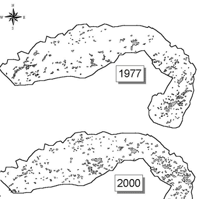
A map of developmental phases shows, that in 2000 optimal phase covers 29%, the aging phase 24%, the selection phase 10%, collapsing phase 13%, the regeneration phase 11% and stem exclusion phase 9%, the transition phase 2%, initial phase 2% of the mapped area. Five permanent transects were established in the 1990s and rerecorded in 2002. They represent different developmental phases. Stem number decreased in most transects mainly due to competitive exclusion in the understorey. Only a few old beech trees died within this short period, mostly in patches of aging, collapsing, or regeneration phase. Beech remained the dominant species (above 90%) in all transects except for one, where ash increased its importance to 7% leaving beech 87%. The size distribution of trees showed an inverse J shape (characteristic of old-growth stands), because of intensive regeneration. In transects representing optimal and aging phases, a close to normal size distribution is characteristic with an extra high density of small diameter classes depending on the strength of understorey stand initiation. Gap dynamics was studied for a 23-year period using aerial photographs taken in 1977 and 2000. They were built in a GIS database so different gap statistics and relationships with topographic variables (elevation, slope, aspect) could be studied. Both the number (230 in
1977, 307 in 2000) and the average size (0.009 ha in 1977, 0.01 ha in 2000) of gaps increased during these 23 years, resulting in a higher proportion of gap area in reserve (4.77% in 1977, 7.18% in 2000). The number of gaps between 0.002 ha and 0.1 ha increased considerably during the 23 years mostly due to gap extension, i.e., former smaller gaps expanded to join with neighbouring gaps. The distribution of gaps among patches of different topographic conditions (elevation, slope, aspect) changed considerably, resulting in larger gap areas e.g., at lower elevations, on steeper, N-NE-facing slopes in 2000 than in 1977. This approach for studying gap dynamics has the strength of making long-term studies possible in the past but needs methodical refinement.