The main objective of our project was to preserve the unique habitats of the Central-Bereg Plain, as well Sphagnum bogs and mires, forest communities (riparian mixed forest, Pannonic woods), wooded pastures, and pastures which have important landscape value and are habitats of rare plant and animal species too.
Direct aims:
• Improvement of the water regime of the bogs (more water, more well-balanced water movement).
• Improvement of the microclimate of the bogs (cooler, more humid microclimate). Complex improvement of the status of other typical habitats of the Bereg (forests, abandoned riverbeds, pastures).
Indirect aims
• To make the wider region/neighborhood of the bogs more natural.
• Complex rehabilitation of the region, which can be the base for ecotouristic development.
• Improvement of sylviculture possibilities.
• Improvement of the possibilities for traditional agriculture.
Altogether 24 actions were carried out within the framework of the project. 14 of them were about maintaining the nature conservation aims, 5 were about keeping in contact with colleagues dealing with similar problems, and about informing the public in the region and in Hungary. 5 further actions were achieved for preparing and supporting these actions.
List of contents and annexes
2. Lists of (I) key-words and (II) abbreviations
3. Executive summary
4. Introduction
4.1. Description of the region, targeted habitats, species
4.2. Project site
4.3. Main conservation issues being targeted (included threats)
4.4. Objectives and methods
4.5. The way the project came about
4.6. Socioeconomic context of the project
4.7. Expected and achieved results
5. Life-project framework
5.1. Description and schematic presentation of working method
5.2. Presentation of Beneficiary, partners and project-organisation
5.3. Description of modifications according to initial proposal
6. Progress, results
6.1. A. Preparatory actions, elaboration of management plans and/or of action plans
6.2. B. Purchase of land
6.3. C. Non-recurring management
6.4. D. Recurring biotope management
6.5. E. Public awareness and dissemination of information
6.6. F. Overall project operation and monitoring
7. Evaluation and conclusions
8. Comments on financial report
9. List of annexes
10. Layman's report
11. After-life conservation plan
9. List of Annexes
Annex 6.B.2-1. Map of planned land-buying.
Annex 6.B.2-2/1. Overview map of completed land-buying and overlap with Natura 2000 sites/1.
Annex 6.B.2-2/2. Overview map of completed land-buying and overlap with Natura 2000 sites/2.
Annex 6.B.2-3. Table of completed land-buying.
Annex 6.B.2-4/1. Detailed map of completed land-buying/1.
Annex 6.B.2-4/2. Detailed map of completed land-buying/2.
Annex 6.B.2-4/3. Detailed map of completed land-buying/3.
Annex 6.B.2-4/4. Detailed map of completed land-buying/4.
Annex 6.B.2-5. Contracts of purchased parcels.
Annex 6.B.2-6. Land Registry sheets.
Annex 6.B.2-7. Confirmation about land prices from notaries of the region and land purchase expert.
Annex 6.B.2-8. Ordinance of the Court of Szabolcs-Szatmár-Bereg County about Gelénes 088/1 and Gelénes 088/2.
Annex 6.C-1. Overview map of C actions.
Annex 6.C.2-1. Map of water closing structures.
Annex 6.C.2-2. Photo documentation of water closing structures.
Annex 6.C.3-1. Map of wildlife fence.
Annex 6.C.3-2. Photo documentation of wildlife fence.
Annex 6.C.4-1. Map of afforestations.
Annex 6.C.4-2. Table of afforestations.
Annex 6.C.5-1. Map of rehabilitated wooded pastures.
Annex 6.C.6-1. Map of rehabilitated pastures.
Annex 6.C.6-2. Table of rehabilitated pastures.
Annex 6.D-1. Overview map of D actions.
Annex 6.D.1-1. Map of managed afforestations.
Annex 6.D.2-1. Map of managed wooded pastures.
Annex 6.D.2-2. Agreement for nature conservation management.
Annex 6.D.3-1. Map of managed pasture.
Annex 6.D.3-2. Agreement for nature conservation management.
Annex 6.E.3-1. One page brochure.
Annex 6.E.3-2. Booklet for farmers.
Annex 6.E.3-3. Laymen's report.
Annex 6.E.4-1. Documentation of Scientific workshop.
Annex 6.E.4-2. Documentation of lecture keeping in schools.
Annex 6.E.4-3. Publication in media.
Annex 6.F.1-1. Organigram of the project.
Annex 6.F.3-1. Research reports (only in digital form)
Annex 6.F.3-2. Report of Hajdú-Bihari Önkormányzatok Vízmű Társulás
Annex 8 ...
There are only selected annexes in the ER Archive:
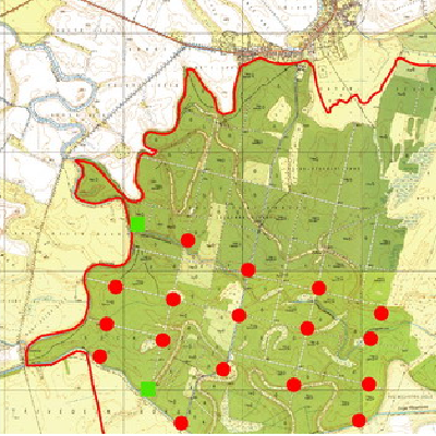
Annex 6.C.2-1. Map of water closing structures and channel dredging
Annex 6.C.2-2. Photo documentation of water closing structures
Groundwater level
Map of piezometers and monitoring wells in Bockerek Forest
Annex 6.C.5-1. Map of rehabilitated wooded pastures
Annex 6.C.6-1. Map of rehabilitated pastures
Find the full documentation at Hortobágyi National Park Directorates.
Contact person: Péter Olajos